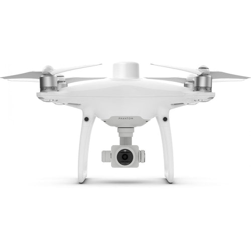
Drones, accessories and extras

DJI Phantom 4 RTK

RTK level precision for DJI's flagship quadcopter range

Accessories

DJI D-RTK2 Ground Station Case(HPRC DJI D-RTK2 Ground Station Case)

£799.00

DJI Phantom 4 RTK

Designed for high-precision mapping and surveying

With its high-precision mapping capabilities, the Phantom 4 RTK is the perfect tool for industrial users. The Phantom 4 RTK is described by DJI as its most compact and accurate low-altitude mapping solution. Sharing a similar camera and form size with the previous Phantom series drones, it also boasts a RTK positioning module, a new TimeSync system and a purpose-built mission-planning app.

Key Features

  • Fewer ground-control points needed for accurate data collection.
  • D-RTK2 mobile station, providing accurate results in areas with bad mobile coverage.
  • Long battery life, providing up to 30 minutes of flight time.
  • Integrated flight-planning app.
  • Operation resumption function, meaning that the flight will automatically resume after battery change.
  • Supports both RTK and PPK solutions.

Next generation mapping with Phantom 4 RTK

The Phantom 4 RTK achieves a new standard for drone accuracy, giving users centimetre-accurate data.

Improved accuracy on image metadata is achieved through centimetre-level positioning data, thanks to a new RTK module.

The flight controller, camera and RTK module are continually aligned by the new TimeSync system, which also ensures that each photo uses the most accurate metadata.

Flight planning application

A new GS RTK app gives control with two planning modes - photography and waypoint flight - as well as a more traditional flight mode.

Pilots can choose the drone’s flight path, while adjusting elements such as speed, altitude and camera parameters.

Furthermore, the app has a range of features such as a strong wind alarm, to warn pilots of adverse weather conditions, while image exposure is kept consistent thanks to a new shutter photography mode.

Precise imaging system

The Phantom 4 RTK can move while taking pictures without the risk of rolling shutter blur. Thanks to its high resolution, the Phantom 4 RTK can achieve a Ground Sample Distance of 2.74cm at 100 metres flight altitude.

D-RTK 2 Mobile Station

The Phantom 4 RTK is complemented by the D-RTK 2 Mobile Station, which gives real-time differential data to the drone and helps to compile the most accurate data for surveying and mapping.

Phantom 4 RTK vs Phantom 4 Advanced/Pro

Key differences between the P4 RTK and other Phantom 4 drones.

One of the biggest differences is that the Phantom 4 RTK has been made with industrial users in mind, thanks to its high-precision mapping abilities, while previous Phantom models were built for professional photographers and hobbyists.

When it comes to the camera, the Phantom 4 RTK has improved capabilities for mapping, thanks to a new lense distortion recording process.

Multiple changes mean that the Phantom 4 RTK remote controller is more versatile and has more features for industrial users. The remote controller has a micro-SD card slot and built-in speaker, while it can be used to connect to the internet for Network RTK with a 4G dongle.

DJI Terra

To take your missions further, the Phantom 4 RTK is compatible with DJI Terra - DJI's new mapping solution.

The photos captured from your DJI drone can now be transformed into digital 3D models or maps.

The models created in DJI Terra can be used in a huge array of applications, including public safety, construction, infrastructure, agriculture and media.

DJI Terra allows you to plan flights prior to your operations, collect and centralise drone data, create 3D maps from selected areas and carry out valuable data analysis.

There are two licences available for DJI Terra - Advanced and Pro. The Pro version (with extra features, such as 3D Reconstruction and 3D Mission Planning) is compatible with the Phantom 4 RTK. You can purchase the Terra licence on its own, or you can buy one of two combo bundles - one 
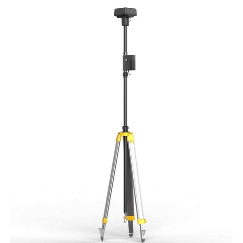
with the Phantom 4 RTK and DJI Terra, and another with these two items plus the D-RTK 2 Mobile Station.

Enquire about DJI Terra Drone Software

This drone land surveying and aerial mapping course will teach you how to perform an accurate drone survey and how to use the data you collect to generate valuable insights for your own organisation or your clients.

  • The key to accuracy when surveying with a drone.
  • Reducing positional errors.
  • Photogrammetry and LiDAR mapping tutorials. 
  • Drone survey data - what you'll collect and how to use it for maximum value.
  • Guidance on when drone surveys will significantly outperform other methodologies.
  • Data processing tips and tricks that give you consistently accurate drone surveys saving you both time and money.

Both theoretical and practical aspects of drone surveying and mapping are covered in the training course to help you get the very most out of your aerial operations.

What this course is not designed to do is to teach you to fly a drone - for a base level of training in that respect - you can check out our A2 CofC and GVC Training Courses.

Drone Surveying Course

DJI D-RTK2 Ground Station Case(HPRC DJI D-RTK2 Ground Station Case)

£799.00

Training by Drone
heliguy™ Training Tools