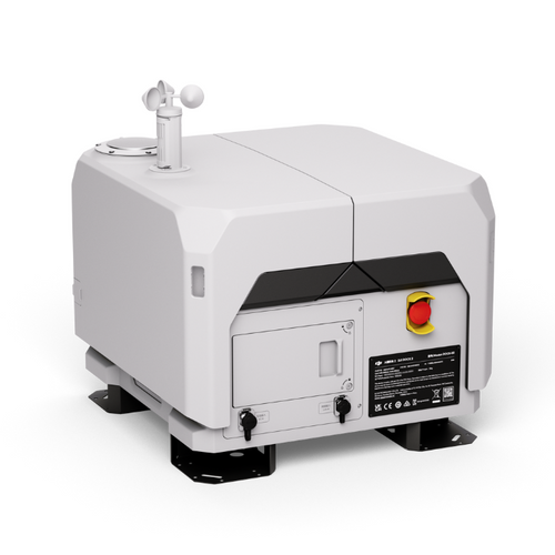
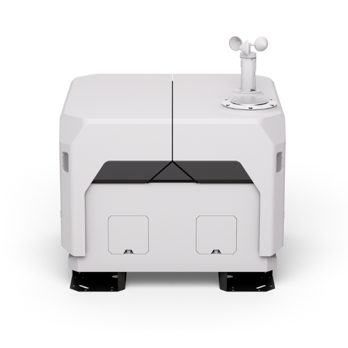
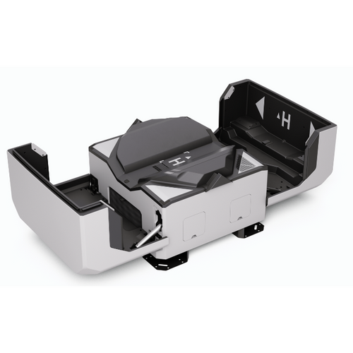
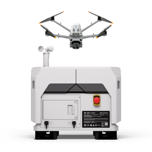
DJI Drone in a Box

DJI Dock 2

Empowering automated and remote drone deployment

Accessories


DJI Dock 2

The DJI Dock 2 is a compact and cost-effective drone-in-a-box solution, designed for remote, automated, and cloud-based operations.

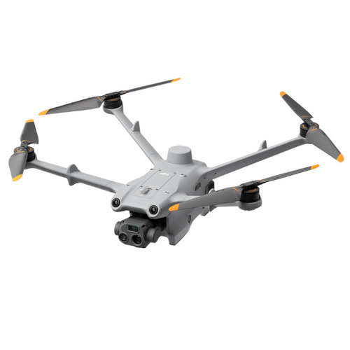
It is compatible with two drones: The DJI Matrice 3D and the DJI Matrice 3TD.

The DJI M3D is designed for high-precision mapping - representing DJI's first dedicated docking station for survey-grade mapping.

The DJI M3TD has RGB and thermal sensors, making it ideal for operations such as public safety, security, and inspection.

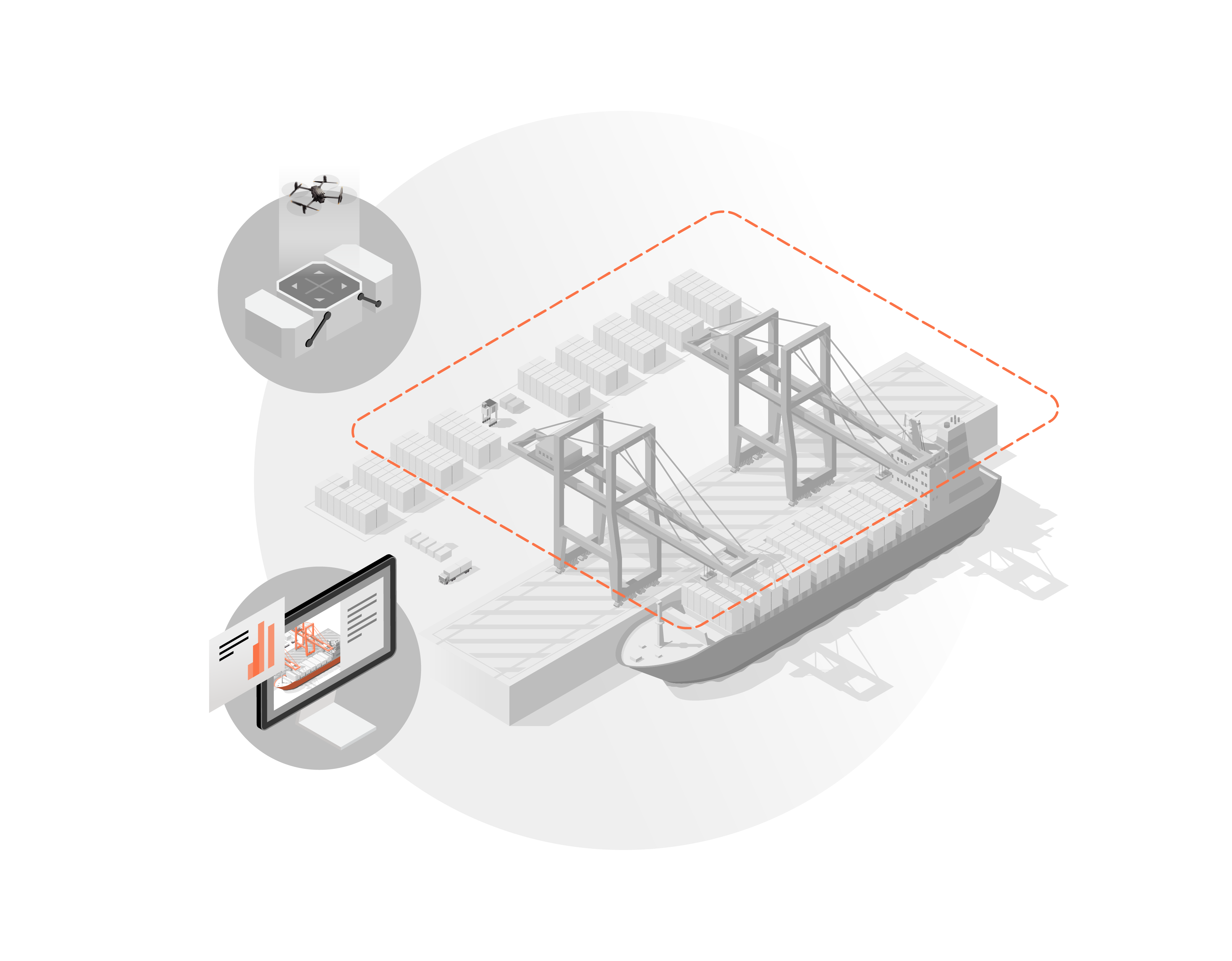
Deploy the DJI Dock with cloud-based software platform DJI FlightHub 2 and benefit from features such as Cloud Mapping, which automatically generates 3D models upon mission completion.

DJI Dock 2 supports third-party software, such as FlytBase and Drone Harmony. 

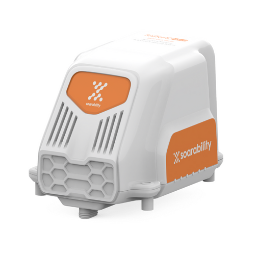
DJI Dock 2 is smaller and more lightweight compared to the original DJI Dock.

As a DJI Dock 2 partner, heliguy™ can help you integrate it into your workflows, including OSC support, survey assistance, and site assessments.


Key Features Of DJI Dock 2

  • Simple Deployment: Lightweight, easy to deploy, vision-based evaluation for quick site selection.
  • Safe And Reliable: IP55 rating, real-time weather change detection, built-in backup battery, six-month maintenance interval, precision landing.
  • High-performance Drones: DJI M3D Series is IP54 rated, 50 minutes of flight time, 10km operating radius, RTK centimeter-level positioning.
  • Versatile Data Collection: DJI M3D engineered for surveying; DJI M3TD built for inspection, public safety, and security.
  • Steady Operation: Quick take-off; Quick charging; Dual-camera monitoring.
  • Cloud-based Operation: Cloud Mapping, Visual Flight Route Editing, AI Spot-check, FlyTo Tasks, Live Flight Controls, Obstacle Bypass.
  • Open Ecosystem: Third-party payloads, edge computing, private deployment, FlightHub 2 coordination with Private Cloud.
  • Key Upgrades: Dock 2 is 68% lighter than original DJI Dock; 25% increase in flight time; and 43% increase in operating radius.  

DJI Dock 2: Powerful Drone Solutions

DJI M3D - Survey Drone

  • Wide-Angle Camera: 4/3 CMOS; 20MP effective pixels; Mechanical Shutter.
  • Tele Camera: 1/2-inch CMOS; 12MP effective pixels; 56x hybrid zoom.

DJI M3TD - Inspection & Public Safety Drone

  • Wide-Angle Camera: 1/1.32" CMOS, 48MP.
  • Tele Camera: 1/2-inch CMOS, 12MP, 56x hybrid zoom.
  • Thermal Sensor: Normal Mode - 640 x 512 @ 30fps; UHR Infrared Image Mode: 1280 × 1024@ 30fps; 28x Digital Zoom.

Both drones:

  • High Accuracy: Integrated RTK Module. ±3cm positioning accuracy.
    IP54:
    Dustproof and waterproof.
  • Large Operating Radius: 50 minutes maximum flight time and 10km maximum effective operating radius. The drones support up to 400 battery cycles.
  • Flight Safety: 6-directional obstacle sensing system.


DJI Dock 2: Easy Deployment In All Weathers

  • Lightweight: DJI Dock 2 weighs 35kg and can transported by two people, enabling flexible installation and reduces installation costs.
  • Efficient Site Evaluation: Before deployment, the aircraft can detect the surrounding environment using vision sensors and determine whether there is strong GNSS signals in the area. This helps to accelerate site selection.
  • IP55 Rating: The Dock 2's IP55 dust and water resistance rating ensures it operates for extended periods of time, even in harsh climates and environments.
  • Environmental Monitoring: Integrated sensors, including rainfall, wind speed, and temperature gauges, perceive real-time weather changes. Receive timely warnings or terminate flight tasks using DJI FlightHub 2.
  • Improved Landing Stability: Using next-gen image recognition technology, the aircraft identifies positioning markers on the Dock's landing pad. The Dock's new slide-ramp centering design further supports precise landing.
  • Built-in Backup Battery: The built-in battery enables the Dock 2 to operate independently for more than five hours, with sufficient time for the drone to return and land.
  • Six-Month Maintenance Interval: DJI Dock 2 only requires maintenance approximately every six months.
  • Abnormal Condition Notifications: Receive email notifications from DJI FlightHub 2 if the DJI Dock 2 and the aircraft encounter task failures or emergencies.
    .

Round-The-Clock Operations

  • Quick Takeoff: DJI Dock 2 features dual RTK antennas, allowing the aircraft to obtain accurate RTH location information without needing an RTK fix. A propeller inspection can be completed in 45 seconds.
  • Rapid Charging: After the aircraft lands back at base, the Dock 2 can charge the drone from 20% to 90% in 32 minutes. This is perfect for continuous operations and ensuring the drone is ready for missions on-demand.
  • Dual-Camera Monitoring: DJI Dock 2 features an internal and external fisheye camera for real-time displays. Remotely observe weather conditions, environmental circumstances, and the aircraft's take-off and landing.


DJI FlightHub 2: Cloud-based Operation 

  • Cloud Mapping: After the drone completes its mission, DJI FlightHub 2 generates a high-precision 3D model based on the flight data. Models can be annotated, measured, and downloaded.
  • Flight Route Editor: Use 3D models for visual flight route editing and preview simulated imaging results.
  • AI Spot-check: Frame a specific area in the 3D model and the drone will compare the area to be captured with the framed area in subsequent automated operations. This ensures repeatable data across multiple flights. 
  • FlyTo Tasks: Use 3D models to automatically plan optimal flight routes. Click on the subject and the aircraft will fly to the destination.
  • Live Flight Controls: With FlightHub 2 or third-party software, control the drone and gimbal remotely from a remote location.
  • Model Comparison: Compare side-by-side models to track project progress over time.
  • Obstacle Bypass: During automatic flights, the drone uses its omnidirectional sensing and automatic bypass functions to enhance flight tasks.

Open Ecosystem

  • Private Deployment With Cloud API: Tailor a customised management system for DJI Dock 2 with Cloud API or quickly connect it to a third-party cloud platform, such as FlytBase or Drone Harmony, to facilitate efficient and convenient private deployment.
  • Third-party Payloads: Connect to third-party payloads to the drone and control them via cloud-based software. The drone can also integrate with a parachute (available separately).
  • Edge Computing: DJI Dock 2 has an edge computing expansion interface that enables the pre-processing of media files and more to improve operational efficiency further.
  • Cloud-to-Cloud Coordination: Through DJI FlightHub 2's FlightHub Sync function, users can easily link it to a third-party cloud platform for flexible management of operation data.
  • DJI TerraAPI: Integrate the powerful mapping capabilities of DJI Terra into your dock management systems. This enables automated 2D/3D reconstruction and customised photo mapping workflows.


DJI Dock 2 Vs DJI Dock 

DJI Dock 2 comes with some key upgrades compared to the original DJI Dock.

  • Smaller Footprint: Dock 2 weighs 34kg compared to DJI Dock's 105kg. This makes Dock 2 easier to transport and better suited for roof deployments.
  • Longer Flight Time/Greater Range: The M3D/M3TD can fly for 50 minutes and has an operation radius of 10km, while the M30 Series for DJI Dock fly for 40 minutes and a 7km operating radius. This is a 25% improvement in flight time and 43% improvement in operating radius
  • More Capability: With the DJI M3D, DJI Dock 2 provides an advanced high-precision mapping solution. DJI Dock mainly deployed for security patrol and inspection. 
  • Smarter Functions: DJI M3D drones automatically bypass obstacles during flight. M30 drones for DJI Dock can only hover or return to start when obstacles are encountered.
  • More Reliable: DJI Dock 2 features a slide-ramp centering design and wireless charging. Dock 1 has push-rod centering and contact charging. DJI Dock 2 is easier to maintain.
  • Faster Takeoff: DJI Dock 2 can take-off without waiting for an RTK fix. DJI Dock 1 must wait for RTK to be fixed.
  • Precise Landing: DJI Dock 2 has next-gen image recognition technology for a more precise landing. DJI Dock mainly relies on RTK for landing. 

DJI Dock 2 Workflow

Automated inspection and remote deployment.

#1 Automated Deployment

DJI Dock 2 will automatically deploy a charged DJI M3D Series drone to conduct your inspection mission.

#2 Remote Data Capture

Automonmously & remotely capture inspection data and images of your target subject.

#3 Real-time Data Sharing

Real-time data sharing through cloud-connected management software, allowing instant data transfer and reporting.

#4 Return to Home and Recharge

DJI M3D Series drone autonomously lands on DJI Dock 2 and begins recharging its batteries for the next mission.

Benefits of Automated Deployment

Operational Flexibility

Conduct persistent, scheduled, round-the-clock data collection or gather spontaneous, on-demand situational awareness whenever you need to. A remote monitoring ecosystem is unbound by the availability of pilots or employees.

Improved Cost Savings

Reduce operational costs and maintain business continuity and operations from anywhere in the world as on-site robots collect consistent, accurate and repeatable data - all managed from afar, centralising data.

Rapid Deployment

Permanently-sited, on-location, autonomous solutions are ready to deploy on-demand, reducing the logistical burden of getting personnel and equipment to site for specific missions.

Enhanced Safety

Remotely-operated drones and robots perform risky tasks in dangerous areas or hard-to-reach locations, keeping personnel away from hazardous situations and enabling collection in otherwise inaccessible zones.

Repeatable Data

Automate missions to ensure your on-site robots collect accurate and repeatable data, more frequently. This is ideal for change monitoring, helping to spot defects early to reduce costs and downtime.

Environmentally Friendly

Remote and automated robotics are an environmentally-friendly way of collecting data. Cutting carbon emissions, they replace helicopters, trucks or argocats - depending on the mission.


The Future of Data Collection

Security / Surveillance

Conduct persistent surveillance along predefined routes or launch for on-demand monitoring.

Operating in an overt or covert capacity, drones increase the surveillance overlap against CCTV infrastructure, reduce blindspots, offer a changeable and unique perspective and provide continuous target tracking.

They are a force multiplier, covering a significantly increased area by comparison to ground-based surveillance equipment and personnel.

Deploy in a proactive manner, as a deterrent, clearance patrol and intelligence gathering or reactively, providing overwatch and coordination of a response.

Where static surveillance sensors can be identified through reconnaissance and invite malicious workarounds, drones benefit from being uniquely positioned.

Mining

Remote monitoring facilitates a range of mining inspection applications, from regularly scheduled inspections to an immediate response in an emergency situation.

Regularly scheduled preventative maintenance is the best assurance of safe and cost-effective mining operations.

Conduct assessments of confined spaces and areas that would otherwise be visually inaccessible or too hazardous for human intervention and detect problems before the damage becomes too severe.

Evaluate the condition of mine shafts, sumps and boreholes; perform in-service remote inspection and avoid costly shutdowns; verify new pipeline construction prior to commissioning; and observe vehicle movements and stockpile measurements.

Launch in an emergency situation, such as a mine collapse or security breach.

Oil and Gas

Minimise refinery downtime, reduce operation and maintenance costs, improve on-site safety and prevent serious failures.

Deploy autonomous drones and robots on pre-scheduled missions to immediately detect leaks, faults, structural damage, environmental hazards, failures and other faults. This information enables maintenance teams to be less reactive and allows them to perform their daily tasks based on timely and accurate data.

Remove workers from potentially hazardous environments: Improving safety, but also save on recruitment and the costs associated with frequent training of staff and insurance.

Remote operations can be vital for offshore rigs: Operate a periodically-manned offshore production platform from a centralised control centre, and remove the problems associated with collecting timely and accurate data from remote and isolated offshore rigs.

On-site robotics can react quickly without human intervention during an emergency, from a fire or leak to another live situation. This improves safety and incident response.

Construction / infrastructure

Monitor site productivity with persistent visual data streams and centralised digital data management.

Onsite robotics enable frequent and repeatable site inspection: Useful for site managers to monitor progress, spot for mistakes, ensure contracted work is performed on time to prevent costly fines and to gather constantly evolving data to feed into digital twins.

Build up to date high-resolution maps and 3D models to obtain a better view of the site, share with stakeholders and collaborate with staff. This data can also be used to track vehicle movements and calculate earthworks and stockpile measurements to improve forecast planning and reduce unnecessary costs.

Remote monitoring and inspection helps to enforce safety protocols, improve on-site staff safety and enables companies to adhere to safety compliance.

Ports and terminals

Remote monitoring improves operations at terminals and enables teams to be more efficient and reactive.

Port facilities need to be secured 24/7: Remote monitoring enables this. Use on-site robotics to secure facilities to prevent the entry of prohibited goods and dangerous objects, monitor sensitive shipments, and control boarding private vehicles or goods trucks.

Scheduled autonomous monitoring of the coastlines also extends a port’s security perimeter.

Conduct frequent routine inspections and continuously monitor shipping lots, manage container inventory and inspect crane operations and unidentified freights.

Access hard-to-reach places to improve safety and increase awareness. Analyse required improvements which are required for infrastructure remotely.

Quickly respond to emergency situations, such as container fires or someone in difficulty in the water. Rapid, real-time situational awareness can be crucial.

Port authorities are responsible for numerous ports. Get eyes on any port of your choice from afar.

Utilities

Leverage remote monitoring to automate utility asset inspection and incident-based alerting.

Proactively inspect critical infrastructure and identify anomalies in real-time to prevent outages and minimise asset downtime. Conduct frequent, repeatable and accurate data for change detection and identify failing equipment and hot spots with thermal and zoom cameras.

Onsite robotics reduce routine visits to remote sites and save on travel time and labour costs.

Improve HSE compliance with automated safety monitoring and conduct proactive theft and vandalism prevention.

Deploy on-site robotics without human intervention to an emergency situation or for storm response.

Monitor and inspect remote substations with 24/7 live access, eliminating windshield time, travel risk and cost. Set-up automated inspection reports to help plan preventative maintenance.

Use video/imagery for audit trails, evidence and to help with incident investigations.

DJI Dock 2 Implementation Pathway

How heliguy™ will support your DJI Dock 2 integration.

Extensive Training

Receive application-focused training from the experienced heliguy™ drone training team, including BVLOS.

Also receive surveying support from the heliguy™ in-house surveying department.

Dock Siting Assessment

Conduct a thorough assessment in conjunction with heliguy™ to ensure you site the Dock(s) at an appropriate location and with the correct infrastructure.

Assessment also includes server and data deliverables.

Safety Management

heliguy™ will assist in the development of a robust safety management system and help you build comprehensive operating procedures.

Legal Authorisation

Obtain the relevant permissions to operate the DJI Dock legally and safely. This includes an Operating Safety Case (OSC), CAA exemption and airspace authorisation.

heliguy™ will guide you throughout this process.


Drone Super Highway

In July 2022, the UK government gave the go-ahead for the world’s largest and longest network of drone superhighways to be built in the UK - a major breakthrough for BVLOS operations

The drone superhighway will develop 165 miles (265km) of ‘drone superhighways’ connecting airspace above Reading, Oxford, Milton Keynes, Cambridge, Coventry, and Rugby over the next two years.

There is an option to expand the corridor to any other locations in the country.

The Skyway superhighway network will help unlock the huge potential offered by unmanned aerial vehicles and be a catalyst to enable growth in the urban air mobility industry.

The project involves Altitude Angel, alongside BT, and a number of UK tech SME's including heliguy™.


sees.ai

In 2021, command & control solution developer sees.ai became the first company in the UK to secure authorisation from the UK CAA to trial a concept for routine BVLOS operations. The permissions came as part of a test project to prove the concept ahead of potentially opening it up to the wider market.

The authorisation enabled sees.ai to fly BVLOS at three nominated sites without needing to pre-authorise each flight. By removing this limitation, the permission fired the starting gun for the next phase of growth of the drone industry.

The authorisation allowed BVLOS flights to occur under 150ft and initially required an observer to remain in visual line of sight with the aircraft and able to communicate with the remote pilot if necessary. By testing the concept in industrial environments for inspection, monitoring and maintenance purposes, sees.ai aimed to prove the safety of its system within this context initially, before extending it to address increasingly challenging missions over time.

Data gathered from the test flights was used to consider the success of the operations and whether the risk and hazard assessments can be used to cover generic risks beyond the three trial sites.

Training by Drone
heliguy™ Training Tools