

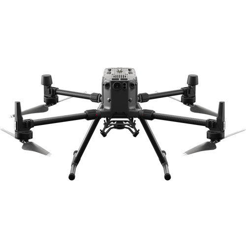
- Deep-dive into how the DJI Zenmuse P1 camera and DJI M300 RTK can transform your surveying workflows;
- Compare its efficiency to the DJI Phantom 4 RTK;
- Learn how the P1 performs in low-light conditions, building quality 3D models in the process;
- Examples of how the P1's top-class sensor can capture sharp, clear and high-resolution imagery for detailed aerial mapping;
- How the M300 RTK enables GCP-free mapping - saving you time and improving safety in the field;
- Smart Oblique Capture mode selects only the imagery that matters - reducing the length of mapping missions and reducing processing time by up to 50%.
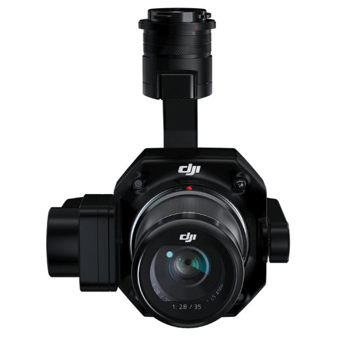
Drone surveying is big business right now, and the DJI Zenmuse P1 is a dedicated photogrammetry payload which transforms aerial mapping workflows.
Key features such as a 45MP full-frame sensor, interchangeable lenses, and the Smart Oblique Capture function ensure super high-resolution data collection, quicker and more effectively than before.

For instance, tests have shown that the P1 and M300 RTK drone combination collects data almost five times faster than the DJI Phantom 4 RTK. It means that the P1-M300 RTK are particularly effective for large-area surveying.
This deep dive into the P1 will highlight the camera's top specs, and how they result in more efficient workflows and improved levels of data capture.
High-resolution Camera For Aerial Surveying
A good camera is essential for aerial surveying: Enter the P1.
The P1 outshines other cameras on the market, thanks to its full-frame sensor, measuring 36 mm x 24 mm.
To put that into perspective, it is seven times the size of the sensor on the Phantom 4 RTK - DJI's compact, low-altitude, all-in-one mapping solution.
The image below show how these two sensor sizes compare:

The P1 also delivers an effective resolution of 45MP, compared to the 20MP sensor on the P4 RTK.
But how does this benefit aerial surveying?
These images show the difference (both using GSD = 2cm/pixel), with the P1 able to capture an area 2.25 times that of the P4 RTK.

This effectively extends the length and width of the image by 1.5 times, giving you the same ground image resolution while requiring a shorter flight route.
This is shown by the two images below - the first being the P4 RTK, and the second being the P1. Notice how the flight route is much shorter for the P1, therefore increasing mission efficiency.


Additionally, the P1 can take a photo every 0.7 s during a flight.
And when mounted on the M300 RTK, the P1 can fly at up to 15m/s for a 1:500 scale mission.
This means that would take only four flights to cover an area of 10km².
Efficiency In Image Collection For 2D Orthomosaics
In fact, the efficiency of the P1 is shown in the next two images.
During a test, both the P1 (with M300) and Phantom 4 RTK were flown for 15 minutes, with the same GSD and under the recommended operating parameters for each aircraft.
The results indicate that the area covered by the P1 is 4.3 times that of the P4 RTK.

For the record, the recommended parameters for each drone are illustrated in the table below:
| P1 | P4 RTK | |
| GSD | 2cm/pixel | 2cm/pixel |
| Front overlap rate | 80% | 80% |
| Side overlap rate | 60% | 70% |
| Flight speed | 15m/s | 5.8m/s |
Surveying At Night
Environments with no or not enough light make it impossible for many aerial surveying cameras or drones to work properly.
But the P1 and M300 RTK change that.
The images below show 3D models created from data captured by the P1 (left) and the Phantom 4 RTK (right) of the same building during a night mission...

...and as you can see, the results are startling, with the models built from P1 data visibly better than the P4 RTK.
So, why the difference?
The P1 benefits from a greater pixel size: With a single pixel being 4.4 um, which is 1.8 times that of the P4 RTK.

The larger pixel size means a larger pixel well which can accommodate more photos, achieving a higher signal-to-noise ratio and exposure latitude. This greatly improves the imaging quality of the camera under low-light conditions.
The P1 also has an adjustable ISO, from 100-25600 (photo and video). This is compared, for instance, to the P4 RTK's ISO range, which is: Video:100-3200 (Auto), 100-6400 (Manual); Photo: 100-3200 (Auto), 100-12800 (Manual).
The results can be seen in the two images below, with the P1 being the first. Notice how much brighter the image is, compared to the P4 RTK.


the P1 is also optimised to handle bright light: After all, aerial surveying is often carried out in the middle of the day when the light is good.
Typically, a higher light ratio poses a major challenge to a camera's latitude. When there is not enough latitude, details can be lost in underexposed and overexposed areas of an image.
This issue is highlighted in the picture below, as captured by the Phantom 4 RTK.

Due to having low latitude, the text on the ground control marking is overexposed - which can't be fixed in post-processing.
In contrast, the photo below, taken by the P1 camera, retains most of the details.

This also means that, during the subsequent aerial triangulation, there will be more matching images.
For example, the below image shows a section of road. The graphic shows that the P1 has more feature points, compared to the P4 RTK, meaning it is easier to match the photos.
![]()
Image Sharpness

Sharp imagery is highly beneficial for surveying: Better imagery equals better maps and models.
Previous drone surveying cameras have failed to deliver this top quality as they have been adapted from consumer-grade cameras. Problems included reduced shutter speeds which resulted in blurry photos in low-light conditions.
In short, they did not meet aerial surveying demands or standards.
But the P1 is different. Specifically designed for drone surveys, the P1 is optimised to have a shutter priority to avoid inaccurate data due to motion blur.
As such, the P1 prioritises the ISO adjustment while maintaining the same shutter speed.
The sharpness of images is also optimised so the edges are going to be very clear, while the accuracy is improved. This round-the-edge sharpness is shown by the images below.
![]()
P1 Lenses

Image quality is vital to producing detailed maps. And a good lens is just as important as the sensor itself.
The P1 can be integrated with lenses with 24, 35 and 50mm focal lengths. All three are made of carbon fibre, are lightweight and compact, and are capable of capturing 8K images.
The 35mm is the most commonly used assembly. This lens assembly has 9 lenses, including three aspheric lenses which greatly reduce distortion, capture sharp imagery, and ensure you can capture accurate data for photogrammetry - as these two pictures show.
Note how in the top image (using P1 + DL Lens) there is little distortion, while in the second shot (P4 RTK), there is visible distortion.


The P1 uses a Global Mechanical Shutter (achieved with a central leaf shutter) to cancel rolling shutter distortion, allowing the camera to handle shutter speeds of up to 1/2000th of a second.
This minimises the impact of the jello effect, compared to a rolling shutter which causes the image to wobble unnaturally.

What's more, combined with the pixel-level image stabilisation provided by the P1's high-accuracy 3-axis stabilised gimbal, the jitter within the exposure time can be kept within one pixel during high-speed flights, ensuring a clear image.
The P1 also supports a wide range of aerial surveying functions during operations, such as auto-focus, temperature compensation, 1-tap infinity focus.
Incidentally, the P4 RTK also benefits from a mechanical shutter.
How The M300 RTK Helps With Surveying
To create an accurate model, a good camera is not enough: Accurate location information is also required.
Aerial surveyors used to have to walk long distances to place a lot of GCPs which would be quite a heavy workload and posed safety risks.
However, the P1 provides accessible surveying technology which requires no GCPs.
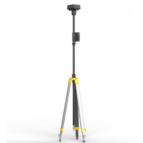
The M300 RTK is equipped with two RTK modules which can provide centimeter-level positioning information, supporting Network RTK and the D-RTK 2 high-precision base station.

Unlike other drones, the M300 RTK makes a GCP-free surveying operation, possible.
The M300 RTK is not the first RTK drone on the market, but few others can go without GCPs. This is because the positioning data obtained by the RTK system is the position of the antenna itself, but we need the position information of the actual photo.
For this reason, the M300 RTK is equipped with a position synchronisaton system called TimeSync 2.0, which continually aligns the flight controller, camera and RTK module.
TimeSync also ensures each photo uses the most accurate metadata and fixes the positioning data to the optical centre of the lens, optimising the results from photogrammetric methods and letting the image achieve CM-level positioning data.
Test results indicate that in a 1:500 aerial surveying operation without GCPs, the drone can achieve a horizontal accuracy of 3cm and a vertical accuracy of 5cm - meeting the requirements of aerial surveying without GCPs.
Smart Oblique Capture
To elevate efficiency, DJI engineers developed the Smart Oblique Capture function. This means that the P1 can continuously capture oblique images from five directions along the flight route.
This can raise its coverage area to 7.5km² per day.
Additionally, the P1 intelligently captures only the photos essential for reconstructions at the edges of the survey area. This improves the post-processing efficiency by 20 to 50%. Find out more here.

What does this mean in the field?
Assume the GSD is the same and the two aircraft are covering the same survey area:
| P1 | P4 RTK | |
| Number of flights | 1 | 2 |
| Flight Details | Smart Oblique Capture | 5 flight routes |
| Number of battery changes | 0 | 1 |
| Time to survey the site | 5 mins 34 sec | 26 mins 15 sec |
| Number of photos | 97 | 427 |
This means that the P1 completed the job 4.7x faster, and captured 53% less photographs. Overall, the P1 reduced the number of photo pixels by 53%.
Not only does this reduce time in the field, but having less images reduces time at the processing stage.
And using DJI Terra, data from the P1 can be used to build high-quality 3D models, bordering on reality capture. Find out more in our in-depth guide to DJI Terra.

As an aside, previous tests by heliguy™ have shown that the P1 can achieve a sub 1cm GSD at a flight height of 50m - resulting in crystal-clear 2D maps, as seen in the image below.

Summary
The P1 and M300 RTK have changed the game when it comes to aerial surveying.
In years gone by, fixed-wing drones have been the go-to solution for surveyors wanting to capture high-resolution data over large areas of ground.
But the high-resolution and efficiency of the P1, coupled with the endurance and weather-resilience of the IP45-rated M300 RTK, means that this DJI surveying solution offers a true alternative to fixed-wing aircraft.
It also represents an evolution of the DJI aerial surveying ecosystem, which started in earnest with the Phantom 4 RTK.
This article might have sounded like we were shining a negative light on the P4 RTK. That was never the intention, because the drone is a reliable surveying aircraft in its own right, used by companies around the world. It is particularly useful for low-altitude small-area surveying, and as an all-in-one solution, it is an extremely accessible drone to use.
But the P1-M300 RTK combination is next level, and offers a truly powerful aerial surveying solution - especially over large areas.
To discuss the DJI surveying ecosystem, contact the heliguy™ enterprise team by phone or email.

very informative comparison
Leave a comment