

- DJI drones have transformed the way that NPS Property Consultants measure coastal realignment;
- Drones collect accurate and repeatable data, providing vital insights about coastal erosion and how to mitigate it;
- The data is gathered much safer with a drone, compared to manually walking a cliff face which could be at risk of collapse;
- Pre-drones, it would take a day to capture data over a 1500m stretch of cliff; it took NPS Property Consultants 24 minutes using the DJI M210 drone - increasing efficiency and cutting costs;
- Drone surveys provide a variety of data, like the 3D model below, for deeper insights and understanding.
Battered by strong seas and high winds, the UK's coastline is under constant attack from erosion.
In England alone, 30% of the shoreline is disappearing - and scientists fear this could accelerate as climate change triggers a rise in sea levels and makes extreme weather more common.
It is an alarming prediction. And the crisis isn't confined to the UK - it is a global problem.
But in recent years, a new technology has emerged in the battle against coastal realignment: Drones.

Unmanned aerial vehicles are being deployed to collect accurate and information-rich data which provides vital insights about the rate of erosion along the shoreline and its associated risks, and the best ways to mitigate it.
An alternative to traditional methods, drones collect this information quicker, safer and cheaper, and provide more varied and robust data sets for deeper insights and understanding, helping professionals make better choices about protecting the coastline.
Cesar Hoyos Franco, a Land Surveyor at NPS Property Consultants, who has used DJI drones to monitor coastal erosion in the UK, said: "For cliff surveying and monitoring, drones are a quick and versatile tool. They increase safety, the speed of data collection, and the output possibilities.
"Drones also allow teams to respond to an emergency cliff landslide in a safe, quick and reliable manner to assess the damage and area affected."
Traditional Methods Vs Drones For Coastal Surveying
Cesar and his colleagues at NPS Property Consultants have witnessed the benefits of using drones for coastal surveying - having deployed the DJI M210 with the Zenmuse X4S camera along the Norfolk coast.

Over the years, parts of the cliff face has been ravaged by the North Sea - losing houses and prime agricultural land, before the construction of a protective rock embankment in 2015.
To help North Norfolk District Council take these protective and preventative measures, NPS Group has measured coastal erosion at key sites along the North Norfolk Coast for a number of years.
In 2018, the company embraced drone technology for this task, switching from the original method of having surveyors walk along and manually measure the cliff edge using a GPS in RTK mode.
And NPS - which has used heliguy™'s drone rental service - has not looked back, discovering that drones can benefit coastal management in numerous ways:
Improved Safety
Previously, the land surveyor would manually take points along the cliff, walking a minimum of two metres back from the cliff edge during clement weather and more when necessary.
The risks, although obvious, were managed: Walking along a cliff in poor condition and at risk of collapse from undercutting needed to be carefully risk-assessed, which all took time.
The drone changed this - covering these potentially dangerous areas, so that staff did not have to.
Enhanced Efficiency
Walking along the cliff top was time-consuming and labour intensive.
For instance, it could take a surveying team the best part of a day to capture data over a 1500m stretch of cliff. The data would be limited, too - yielding only a 2D map of the survey area.
Using the drone, the team covered the same stretch in just 24 minutes. Flying at a height of 100m, NPS conducted two 12 minute flights, capturing a total of 763 images with a ground sample distance (GSD) of 2.5cm/pixel.

Cesar said: "The drone has enabled us to increase our survey speed and cover larger areas in less time. This is reflected by a reduction in costs."
Better Quality Data
Put simply, drones have enabled NPS to collect better quality data, which in turn has empowered the local authority to make more informed decisions.
For instance, this video clearly shows how the cliff has retreated over time: A view that would be difficult - and costly - to achievable using alternative methods.
Before drones, the method of walking the cliff edge presented numerous limitations for data capture: Primarily the lack of precision and the inability to check the accuracy of the results obtained.
Irregular structures were always difficult and time consuming to survey accurately, so the drone system has improved the accuracy beyond measure.
Cesar said: "Although outputs were acceptable for the task, there was a lack of options when presenting the data to the client.
"It was only possible to produce planimetric results, showing the horizontal position of features. We could only offer a *.dxf file with a single line indicating the current position of the cliff."
But this all changed with the drone.
Equipped with the X4S camera, the M210 was able to fly low and close to the cliff edge to collect accurate data which could be exported in a variety of ways for a range of analysis.
Outputs generated on the cliffs included Point Cloud, Orthophoto, Digital Elevation Model and Digital Surface Model files. This data could be transformed into 2D and 3D maps and models, better informing local decision-makers about future remedial measures.
Cesar said: "This kind of output data allows us to provide our client with a full range of analysis options, such as sections, profiles, volumetric calculations, risk erosion rates, and 2D/3D measurements. It also allows a 3D visualisation via 3D models, flybys, and point-cloud views.

"This data - all with survey-grade accuracy - can be used to assess the distance and risk to properties or other assets, and the 3D realistic reproduction facilitates the understanding for all parties involved on the cliff maintenance.
"All this data can be directly integrated in CAD or GIS package for different analysis."
Repeatable Data
Measuring coastal erosion is a constant process, with regular monitoring and updates required. Drones have enabled NPS to collect this repeatable data, eliminating the guesswork in the process.
Cesar said: "Every six months, up-to-date information is provided on the state of cliff realignment due to maritime erosion. Using the drone, we repeat the same flight path at the same altitude with the same GCP (Ground Control Points) to obtain the same GSD. This enables us to collect quality and tangible results every year, and show what has changed over time - as these images below show.


"Previously, due to the risk of collapse from the cliff, our surveyors had to keep a safe distance from the edge. This manual method didn’t provide a high level of accurate or repeatable data as the surveyor was just walking next to the cliff and following a slightly different path each time.
"But the drone does this autonomously, following the same predefined flight path each time, providing us with this quality repeatable and comparable data."
Using Drone Data For Coastal Management
The team’s use of drone technology to help monitor cliff realignment and climate change on the North Norfolk Coast has helped to inform and shape coastal management planning in North Yorkshire.
For instance, the drone data has added to the information available for the local authority to manage coastal realignment, buying time for the community to manage coastal change.
It is a great example of how drone technology can be used to increase community engagement in decision-making and help deal with important and technical planning issues of erosion on the coast.

Cesar said: "The great variety of outputs generated by the drone - in both 2D and 3D - facilitates decision-making to the client about what their future actions should be in this regard. In addition, these data sets are homogeneous, not generic, as those obtained with classical methods.
"The use of the drone has eliminated the risk to surveyors, reduced time on site and subsequently led to cost savings - together with improved data and the ability to produce more meaningful CAD plans/sections at any point on the drone’s flight path.
"This has improved the value for money and helped professionals make better choices about protecting the coastline."
The NPS Planning Consultancy Team, in Norwich, was commended in the Excellence in Tech Within Planning category at the RTPI Planning Excellence Awards for their Drones in Coastal Management Planning in North Norfolk scheme in 2019.
Best Drones For Measuring Coastal Erosion
There are numerous drones and payloads which are ideal for coastal surveying. These include:
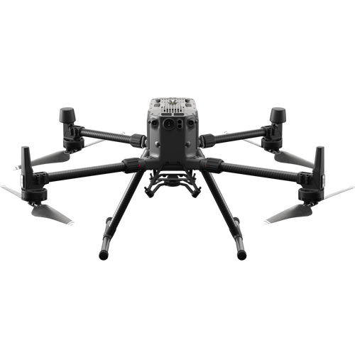
DJI M300 RTK and P1 Photogrammetry Camera
The M300 RTK is DJI's flagship commercial platform.

Its key features include up to 55 minutes of flight time, an IP45 rating, and enhanced flight safety and redundancy features. A highly-versatile aircraft which can be used for a range of mission scenarios, it has the ability to carry up to three payloads simultaneously.
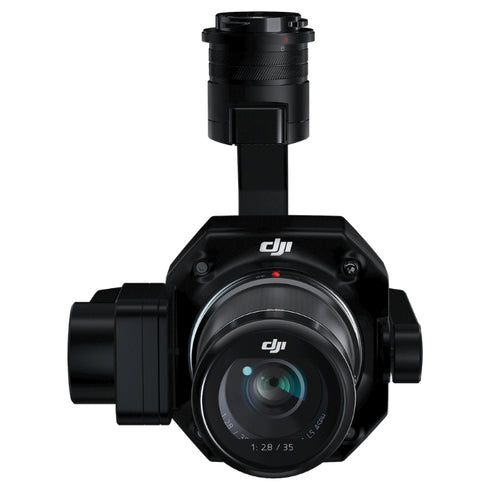
One of these payloads is the DJI Zenmuse P1, a specialist and dedicated photogrammetry camera.

Photogrammetry involves the capture of high-resolution photographs to recreate a survey area. These images are processed and stitched together using sophisticated software to create realistic, geo-referenced, and measurable 3D models of the real world.
RELATED ARTICLE: M300 RTK And P1 Case Study - Exclusive Data Sets
The P1 is perfect for this, thanks to its high-resolution 45MP full-frame sensor. Other key features include:
- Achieve 3cm horizontal and 5cm vertical accuracies, without any GCPs;
- Cover 3km² in a single flight;
- 3-axis stabilised gimbal with Smart Oblique Capture, ideal for large surveying sites;
- Global mechanical shutter with a shutter speed of 1/2000 seconds;
- Interchangeable fixed-focus lenses (24/35/50mm).
The P1 can be used in conjunction with the DJI Terra mapping software package.
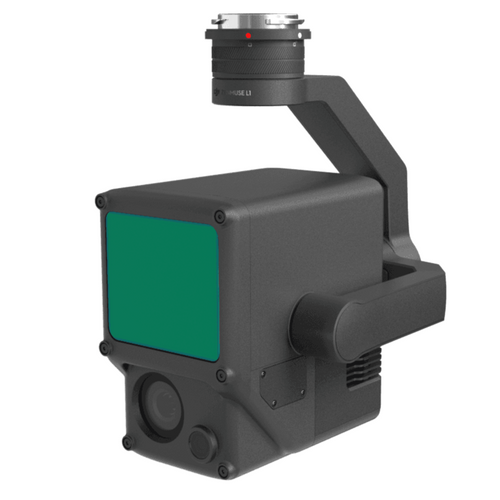
DJI M300 RTK and L1 LiDAR Sensor
LiDAR is a valuable surveying technique for monitoring coastal erosion, creating highly-accurate point clouds which can be converted into 3D models. It is particularly effective for creating Digital Terrain Models (DTM); a model of the bare earth (without any objects/buildings in it) containing elevation data of the terrain.

Historically, LiDAR has been an expensive and complex technique to deploy, but the recent release of the DJI Zenmuse L1 has pushed drone LiDAR into a more accessible and affordable sphere.
The L1 is a multi-purpose solution, featuring a LiDAR module, a 20MP RGB camera, and a high-accuracy IMU. It is engineered for the M300 RTK drone.
RELATED ARTICLE: M300 RTK And L1 Case Study - Exclusive LiDAR Data Sets
Its key specs include:
- Cover up to 2 km² in a single flight
- IP44 weather-protection rating
- Supports three returns
- Point Rate of 240,000 pts/s
- 5cm vertical accuracy / 10cm horizontal accuracy
- 450m Detection Range
- Point Cloud LiveView
The L1 can also be used in conjunction with DJI Terra. This enables surveyors to access 3D data, details of complex structures, and precise visual reconstructions.
DJI Phantom 4 RTK
The DJI Phantom 4 RTK is a purpose-built surveying solution, especially suited to low-altitude missions. It provides a great option for those who are new to aerial mapping and/or those who are covering smaller survey sites.

Its key features include:
- RTK module
- 20MP 1" CMOS sensor
- Mechanical shutter reduces risk of rolling shutter blur
- TimeSync System, which aligns the flight controller, camera, and RTK module
- Compatible with DJI Terra
Drones For Measuring Coastal Erosion - Summary
The threat of coastal erosion is all too real; just ask the communities which suffer from rapidly reseeding shorelines and face the constant threat of losing property and possessions to Mother Nature.
Thankfully, there are techniques in place to mitigate this risk. And while coastal surveying is not a new practice, the emergence of drone technology has transformed this methodology.
Deploying UAS along the coast is a safer, more efficient, and cost-effective solution compared to manually walking along and measuring a cliff face which is at risk of collapse. It is also a more accessible technique than using manned aviation to collect aerial imagery.
By flying at low altitude, drones are able to gather highly-accurate data which can produce a range of outputs to enrich decision-making and coastal-defence strategy.
Coastal erosion won't just disappear, in fact with climate change it is likely to increase in future, but drones provide a modern solution to an age-old problem - and continued innovation in the UAS industry will only serve to further improve coastal management and help develop better informed strategies and improve decision-making.

Leave a comment