

- In-depth guide to drone multispectral imagery;
- Find out what it is and how it helps farmers and other environmental professionals make timely and informed decisions - enabling increased yields, productivity, and land management solutions;
- How various multispectral bands can be used to reveal different insights and obtain information which is invisible to the human eye;
- Learn about vegetation indices and how their can provide vital information;
- Find out why drones are effective multispectral tools, and which ones are the best solutions, including the new DJI Mavic 3 Multispectral.
DJI has recently released the Mavic 3 Multispectral: A powerful drone engineered for precision agriculture and environmental monitoring.
But what exactly is multispectral imaging, and how can this data be used by farmers, ergonomists, and other environmental professionals to achieve enhanced results - from more effective crop production to better land management?

And how can multispectral drones, like the DJI Mavic 3M, streamline this process and collect accurate, efficient, and repeatable multispectral data?
Find out in this guide to using drones for multispectral imaging.
What Is Multispectral Imaging?
Multispectral imaging captures and records light across a range of wavelengths within the electromagnetic spectrum - including those outside of the visible spectrum, such as infrared and ultra-violet.

As a result, multispectral imaging provides the ability to extract additional information which the human eye or standard industrial vision cameras fail to capture.
And this extra information has tremendous value to those in agriculture, forestry, and land management.
Benefits Of Using Multispectral Imaging For Agriculture, Forestry And Land Management
By having access to multispectral data - and the subsequently obtained Vegetation Index data such as NDRE and NDVI (more on this later) - farmers can obtain deeper, more accurate and timely insights to help identify problem areas in a field, uch as sections that are experiencing stress due to disease, pests, water stress, or nutrient deficiencies.

In turn, this data enables farmers to detect issues early and make informed and more targeted management decisions that can improve crop yields, save resources, and reduce waste and costs.
In forestry, multispectral imagery can be used to identify and map various features of the forest, such as tree species, tree health, and biomass. It can also be used to detect and monitor changes in the forest over time, such as the spread of disease or the impact of logging. Additionally, multispectral imagery can be used to estimate the volume of timber in a forest, which is important for sustainable forestry management.

And in land management, multispectral imagery can be used to identify and map different types of vegetation, land cover, and land use. It can also be used to detect and monitor changes in the land over time, such as urbanisation, deforestation, and land degradation.
This information can be used to make informed decisions about land-use planning, conservation, and resource management. Additionally, multispectral imagery can be used to identify and map natural resources, such as minerals and water, which is important for sustainable land management.
Multispectral Bands And Their Insights
As we've mentioned, multispectral imaging captures images in various spectral bands - or ranges of wavelengths - of the electromagnetic spectrum.
Some of the most commonly-used bands for multispectral imaging in agriculture, forestry, and land management include:
| Spectral Band | Wave Length | Application |
| Red | 600-700nm | Used to detect vegetative growth and vigor, crop type, humidity, and generates leaf area index. |
| Near-infrared | 700-900nm | Used to measure plant health and productivity. |
| Red-edge | 700-780nm |
Used to detect crop stress, can indicate changes in chlorophyll content. |
| Green | 500-600nm | Used to measure canopy cover and detect weed growth. |
| Blue | 450-500nm | Used to detect water stress, disease, and large differences in plant health. |
Multispectral cameras are able to present us with a separate photograph of each band.
The Mavic 3 Multispectral drone, for instance, is able to capture the Red, Near-infrared, Red Edge and Green bands. It can create a separate image for each of these bands and this data can be processed to build a separate orthomosiac for each band.
Isolating these bands is useful for analysing an object's spectral signature: In agriculture, this process helps to monitor plant health.
For example, healthy plants reflect a smaller quantity of red light but a larger amount of near-infrared light (which humans can't detect, but multispectral imaging can), whereas the opposite is true for stressed or dead plants.

Therefore, by using multispectral imaging, the levels of near-infrared can be observed, enabling agriculture professionals to monitor plant health and track changes earlier to identify areas of a field that may require attention or specific areas that need fertilisation and water.
Using Vegetation Index Data
Vegetation indices are widely used in remote sensing and precision agriculture to provide a more in-depth view of vegetation health and productivity and to track changes over time.
They are a spectral imaging transformation of two or more image bands to enhance analysis of various characteristics of vegetation, such as biomass, photosynthetic activity, and water stress.

The different indices provide different information, and by using a combination of indices, a more comprehensive understanding of the vegetation state can be obtained.
Some of the most commonly used vegetation indices include:
| Index | What it tells you | Uses | Formula (Electromagnetic Spectrum Bands) |
| NDVI |
The most commonly used vegetation index that gives insight into chlorophyll content of plants. It is an indicator that shows the greenness, density and health of vegetation, and can be used for estimating crop vigor during the early stages. |
• Plant vigor • Differences in soil water availability • Foliar nutrient content (when water is not limiting) • Yield potential |
(Nir-Red)/(Nir+Red) |
| NDRE | Research has shown that this index gives insight and changes into chlorophyll content of crops later into the growing season. It detects variations in crop health at more advanced stages because it uses red-edged light that can penetrate leaves much deeper than red light (used in NDVI). Where there is more intense canopy, it is advisable to use NDRE. |
• Leaf chlorophyll content • Plant vigor • Stress detection • Fertiliser demand • Nitrogen uptake |
(Nir-RedEdge)/Nir+RedEdge) |
| OSAVI | Soil conditions are important factors in plant health during early growth stages, especially if crops are planted sparsely. This index takes soil condition into consideration, and is a good indicator of chlorophyll content of crops in their early growth stages. |
• Differentiate soil pixels • Accounts for non-linear interactions of light between soil and vegetation • Used as a structural index for some combined indices designed for chlorophyll detection |
(Nir-Red)/(Nir+Red+0.16) |
| GNDVI |
This index uses green wave to calculate chlorophyll content instead of red in NDVI, and has been shown in research to be more stable than the NDVI index. |
• Determine water and nitrogen uptake in the crop canopy |
(Nir-Green)/(Nir+Green) |
Vegetation Index Datasets And Analysis
So, how do these vegetation indices playout in the real world to enable constructive and predictive analysis? Find out below.
RGB
The RGB image offers a true-to-life visualisation of the field. It provides an effective, at-a-glance view, but as you'll see, it does not provide the deep insights afforded by utilising various vegetation indices.

NDVI
The data set takes on a different look when switching to NDVI.

NDVI can be used to shows plant vigor. Values close to 1 show greater vegetation cover, while those nearer to 0 highlights areas with little vegetation, early stages of cultivation, bare soil, or diseased plants.
NDRE
High values of NDRE represent higher levels of leaf chlorophyll content. Soil typically has the lowest values, unhealthy plants have intermediate values, and healthy plants have the highest values.

GNDVI
As with NDVI, the values given by this index also range from -1 to 1. Values between -1 and 0 are associated with the presence of water or bare soil.

OSAVI
OSAVI values can range from -1 to 1. High OSAVI values indicate denser, healthier vegetation, whereas lower values indicate less vigor.

Why Use Drones For Multispectral Imaging
Multispectral imaging is not new. However, using a drone to capture this data has multiple benefits compared to traditional methods.
These include:
Flexibility
Drones can reach places that are difficult or impossible for ground-based vehicles or manned aircraft to access, such as steep terrain, dense forests, or sensitive ecological areas. They can also fly at low altitudes to capture high-resolution images.
Cost-effective
Drones are less expensive to operate than manned aircraft, and they can be used to collect data more frequently and at a lower cost than traditional data collection methods.

Safety
Drones can be used to collect data in areas that may be too hazardous for human operators, such as active wildfires or natural disasters.
Speed
Drones can cover large areas quickly, allowing for efficient data collection and rapid response in emergency or time-sensitive situations.
Efficiency
By using multispectral cameras, drones can collect data in multiple spectral bands at the same time, allowing for more detailed and informative images.
Repeatability
Drones can cover the same area multiple times at different time intervals, allowing for tracking changes over time.

Autonomy
Drones can be programmed to fly pre-defined flight paths, allowing for more consistent and accurate data collection.
In summary, drones offer a flexible, cost-effective, safe, and efficient way to collect multispectral data that can be used to support a variety of applications, such as precision agriculture, environmental monitoring, and natural resource management.
Best Drones For Multispectral Imaging
There are numerous drones available for multispectral imaging.
One of these platforms is the DJI M300 RTK, which can be integrated with third-party multispectral sensors from the likes of MicaSense and SlantRange. The M300 RTK is a versatile drone, which can carry a range of payloads (such as thermal, zoom, LiDAR, photogrammetry, gas detectors) for a range of missions.

DJI has also released the DJI Mavic 3 Multispectral - dedicated to multispectral imaging and aerial surveying. For this reason, we will detail the drone below.

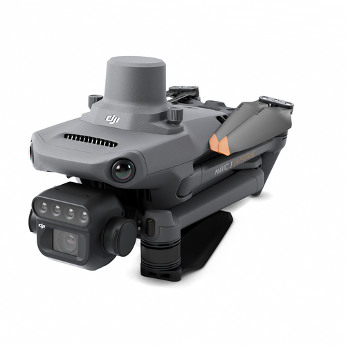
DJI Mavic 3 Multispectral
The advantages of using drones to collect multispectral data is epitomised by the DJI Mavic 3 Multispectral, which can be used for digital farmland management, intelligent field scouting, and precision agriculture.
Highlights of the Mavic 3M include:
High Resolution Dual Image Capabilities
The Mavic 3M has a 20MP RGB camera and four 5MP multispectral sensors.

The table below highlights the camera specifications in more detail.
| Camera | Specifications |
| Visual Camera |
• 4/3 inch CMOS, 20MP • Large pixel size: 3.3um, increasing daily operation time • Mechanical shutter - avoid rolling shutter effect • Minimum photo interval - 0.7s • Flight control, the camera, and RTK module sync in microseconds • Utilise the RTK module to achieve centimetre-level GCP-free mapping accuracy |
| Multispectral Cameras |
Four multispectral cameras, 1/2.8 CMOS, 5MP • Near-infrared (NIR): 860 nm ± 26 nm; • Red (R): 650 nm ± 16 nm; • Red Edge (RE): 730 nm ± 16 nm; • Green (G): 560 nm ± 16 nm |
This enables applications such as precision aerial surveying, crop-growth monitoring, and natural resource surveys.
When enabled, RGB camera view and vegetation indices (NDVI/GNDVI/NDRE) can be displayed side-by-side. Capture and view these insights in real-time.
All-in-one platform
For the first time, the aircraft, a high-resolution RGB camera, multispectral camera, and the RTK module are highly integrated on a small multi-rotor drone, which is small, compact and foldable for easy transportation and quick deployment.

No Calibration Panel Is Required
Built-in sunlight sensor collects the intensity of the sunlight in real time, without the need for a calibration panel, which greatly expands the working time and simplifies the work flow.
Mission Planning
Automate data capture. Features include real-time terrain follow: The drone creates a terrain model in real-time and automatically adjusts the flight altitude to maintain a relatively constant altitude with the terrain.

Efficient And Safe Surveying
Collect more data in one mission: A flight time of up to 42 minutes (with RTK module) enables the drone to cover more than 2 square kilometres in a single flight.
The drone has omnidirectional obstacle sensing and O3 transmission for a strong and stable connection.
Several Deliverables
Generate 2D maps, 3D models and multispectral indices maps through DJI Terra.
Summary
Multispectral imaging is an essential tool for agriculture, land management, and forestry.
It provides deep insights which can be used to more effectively monitor plant health, soil conditions, and biodiversity, which in turn can result in enhanced yields, better productivity, and increased profits.
Drones enable multispectral data to be collected efficiently, safely, accurately, cost-effectively, and repeatedly - and the new DJI Mavic 3M is a great tool for this.
Contact us to discuss drone multispectral imaging and to add multispectral drones to your operations.

Leave a comment