

- Drones with a thermal camera are helping to increase efficiency, improve safety, and maximise return on investment;
- Professionals are benefiting from drones and thermal cameras across a range of sectors, such as public safety and industrial inspection;
- Key tools include the DJI M300 RTK drone, integrated with a H20T camera, the DJI M30T, and the DJI Mavic 3 Thermal;
- Read success stories which highlight the benefits of this technology;
- Find out how DJI Gold Partner heliguy™ can support your enterprise drone programme.
From finding missing people to helping firefighters tackle a blaze, a drone equipped with a thermal camera has become a key tool.
Professionals across a range of sectors - including public safety, industry, and agriculture - are harnessing the power of this technology.

Thermal drones saves lives, increase safety, boost efficiency, gather crucial real-time insights, and maximise return on investment.
Recognising this potential, DJI has invested significantly in the thermal-imaging field.
This includes the H20T thermal camera, specifically engineered for the new M300 RTK drone.

Other powerful thermal cameras include the Zenmuse XT2 sensor and the FLIR Vue TZ20-R (dual thermal zoom) for the M300 RTK and M200 drone series.
Meanwhile, the M30T, Mavic 3 Thermal, and Mavic 2 Enterprise Advanced drone have thermal cameras built into them and are lightweight alternatives to the Matrice options.
How A Thermal Drone Can Help You
Operators using a drone with a thermal imaging camera have seen outstanding results, and the success stories have duly followed.
RELATED ARTICLE: A Guide To Thermal Drone Imaging
Commander Tom Madigan, of Alameda County Sheriff’s Office, told Senators in California that he couldn’t underestimate the power of a drone with a thermal camera. Read the full story here.
Meanwhile, Wiltshire Police said that a missing teenage girl would have been found dead if it wasn't for a drone with thermal capabilities.
This post will explore the advantages of thermal camera drones, and look deeper at the options available.
1: Finding Missing People
Drones with thermal cameras have a great track record of finding missing people; in many cases where ground searches have failed.
In one example, Wiltshire Police used its drone to find a missing pensioner, believed to be at risk of harm.
A large on-the-ground team was sent to search a wooded area near to where she was last seen.
The police drone, equipped with a thermal-imaging camera, was dispatched and arrived at the scene around 30 minutes later.
Within an hour, the drone located a heat source on the edge of a wooded area.
On closer inspection, the outline of a person laying on the ground could be seen.
The drone hovered over the area directly above to guide in officers on the ground and the patient was located.
In another case, team members from search and rescue, police and fire teamed up to search for a missing 88-year-old man who had gone missing from his home in Brownsville, Texas.
A drone was deployed as part of their efforts.
At 11pm, the drone located him in tall grass in a field by a levee, a location that might have been difficult to locate by searchers working only with the information they could gather on foot and by car.

Brownsville’s Deputy Fire Chief Cesar Pedraza said he felt that the use of the drone saved the man’s life.
2: Fighting Fires
A drone with a thermal camera is an incredibly useful tool for firefighters.
This technology can see through smoke and detect hotspots, helping to provide vital situational awareness.
This in turn shapes deployment strategy and improves crew safety.
London Fire Brigade demonstrated how effective this can be during a major warehouse fire in Beckenham.
Sending a DJI M210 and Zenmuse XT2 above the incident, firefighters accessed real-time aerial views of the blaze.
The drone helped to monitor the extent of the fire.
The image on the left shows the drone providing a view from above, but the thermal image gives a clearer insight about the situation - helping firefighters see through the smoke and identify the key hotspots.

The bright pink, orange and red areas in the thermal image showed what LFB described as ‘the deep-seated pockets of fire’ that the crews were tackling.
Meanwhile, Captain Ryan Gifford, of Sacramento Metropolitan Fire District, explained how this technology helped crews fight a ‘fairly complicated’ structure fire.
He said: “Thermal imaging (on a drone) helps find a persistent hotspot which crews on the ground aren’t able to locate.
"By jumping up over the top of a structure and using thermal imaging we can get them to where they need to be.”

3: Law Enforcement
A drone with a thermal camera helped Lincolnshire Police land its first successful prosecution using a UAV.
The technology was deployed to uncover a cannabis farm, unveiling an operation which was capable of producing more than £50,000 worth of the Class B drug.
A police spokesman said: "We turned up and flew the drone 400ft across an open field, before hovering 50m from the property.
"The heat source was obvious and we scrolled through our different filters to highlight the heat in a number of different spectrums.
"The filming from the drone took one minute and 20 seconds, and it was only in the air for five minutes from start to finish.
“From here we passed the footage on to the investigating team who used this to get a court warrant.
“It was great to be able to show this evidence in court as it provides a visual that couldn’t really have been done in any other way.
"Admittedly, the National Police Air Service helicopter could have done this, but this would have been at a cost of about £3,000 per hour, and we did this as part of our routine duties."
4: Infrastructure Inspections
When it comes to utility or building inspections, a drone equipped with a thermal camera can be a game-changer.
Thermal cameras enable you to see missing or damaged installation, water under roof membranes, external electrical issues, failed windows and many other problems.
Thermal drones also allow operators to reach tough-to-access spots quickly, easily, and safely.

Drones with thermal cameras all also a vital tool for solar-panel inspections.
They can be used to identify manufacturing defects, cracks, faulty inter-connectors, and temporary shadowing.
And the bonus; they can collect this data much quicker than traditional hand-held methods.

One study has shown that drones collect data more than 50x faster than manual methods. This increased efficiency helps to boost profitability.
5: Precision Agriculture
Drones have become a key tool for agriculture, helping to identify in-field variability, improve farming practices, and optimise agronomic inputs. Equipping a UAV with a thermal camera can have numerous benefits.
For instance, optimising irrigation can be achieved by using thermal images to map the variability of water potential in the field.

Thermal cameras can also be used to detect water stress in crops, as stressed vegetation has an increased temperature.
Usually, for agriculture, the terrain is scanned by using satellites with multispectral and thermal cameras.
For precision agriculture, due to the needed high spatial resolution, drones are more suitable platforms than satellites for scanning.
They offer much greater flexibility in mission planning than satellites and are also cheaper and quicker to deploy.
Best Drone With Thermal Camera
So, the case for using a drone with a thermal sensor has been made. But which DJI products are best suited for this type of work?
A look through the enterprise ecosystem picks out four prime candidates – the M300 RTK, the M30T, M200 Series V2 and the Mavic 2 Enterprise Advanced.
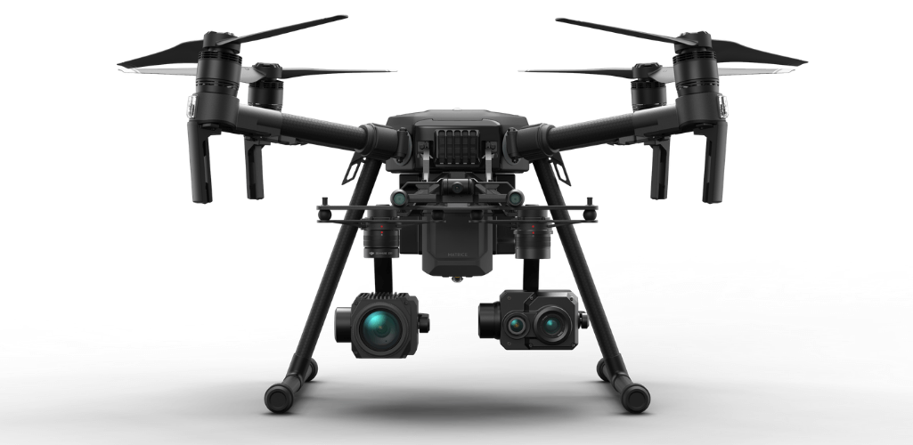
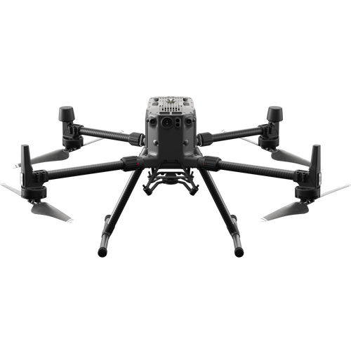
DJI M300 RTK
The M300 RTK is DJI's flagship commercial drone.

It has a flight time of up to 55 minutes (no payload), can carry up to three cameras at once, and has an IP45 weather rating.
The M300 RTK can be integrated with the H20T, XT2, and TZ20 thermal cameras.
DJI M30 Series: M30T
The DJI M30T is part of the DJI M30 Series. It has the power and performance of the M300 RTK but the portability of the Mavic 2 Enterprise Advanced, making it a quickly-deployable, highly-dependable thermal drone.

The M30T has an enhanced IP rating, of IP55; can fly for a maximum of 41 minutes; and can be used with the DJI RC Plus controller, with seven-inch screen.
While the M300 RTK has the ability to switch payloads - making it extremely versatile - the M30T has a fixed camera, although additional modules, like the LP12 loudspeaker/spotlight, can be attached to the top of the aircraft. But while the M30T's camera is fixed, it has decent capabilities:
- Wide Camera: Equivalent Focal Length: 24 mm, DFOV: 84°; 12 MP 1/2'' CMOS Sensor; Video Resolution: 4K/30fps.
- Zoom Camera: 48 MP 1/2'' CMOS Sensor; 5x-16x Optical Zoom, 200x Max. Hybrid Zoom; Photo Resolution: 8K; Video Resolution: 4K/30fps.
- Thermal Imaging Camera: Equivalent Focal Length: 40 mm; Resolution: 640 x 512 or Infrared Image Super-resolution Mode: 1280 x 1024; Frame Rate: 30fps; Measurement Accuracy: ±2°C or ±2%.
- Laser Rangefinder: Range: 3 m - 1200 m; Accuracy: ±(0.2m+D×0.15%).
This video shows how Lincolnshire Police used the M30T's thermal capabilities to find two missing people.
Meanwhile** our operational success continues with our new @DJIEnterprise #M30. Video from Sunday shows two High Risk Missing Persons, located in the dark, in a field by the A15 #thermal #camera. This #drone find ensured quick safeguarding & helps free up @LincsPolice officers. pic.twitter.com/Vv0h1bPLwK
— Lincolnshire Police Drones (@LincsCOPter) June 23, 2022
DJI Mavic 3 Thermal
The DJI Mavic 3 Thermal is part of the Mavic 3 Enterprise Series.
It is a lightweight, compact and foldable a drone, perfect for rapid deployment and easy transportation.

The Mavic 3 Thermal has a built-in camera, with the following features:
- Thermal Sensor: Resolution 640 x 512 @ 30fps.
- Wide Angle: Equivalent Focal Length: 24mm, 48MP.
- Zoom: Equivalent Focal Length: 162mm, 12MP, 56x Hybrid Zoom.
The Mavic 3 Thermal can be integrated with numerous accessories, such as a loudspeaker (ideal for public safety/search and rescue operations) and an RTK Module, making it particularly useful for thermal mapping.
With its longer flight time (up to 45 minutes) and enhanced visual zoom capabilities, the Mavic 3 Thermal is an upgraded version of the Mavic 2 Enterprise Advanced, which is featured later in this blog. Read our Mavic 3 Thermal vs Mavic 2 Enterprise Advanced article for an in-depth comparison between the two platforms.
DJI Matrice 200 Series V2
The M200 Series V2 are the older siblings of the M300 RTK.
While the M300 RTK is the new kid on the block, there is still a place for the Matrice 200 Series; the M210 is pictured below with the XT2 and Z30 zoom camera.
The M200 Series V2 are still reliable enterprise drones, with an IP43 rating, and around 24 minutes of flight time with payload.
The M200 drone can carry one payload, while the M210 and M210 RTK can fly with two cameras at a time.
All three options can be integrated with the XT2, as well as the TZ20.
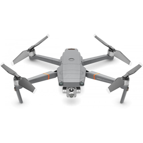
DJI Mavic 2 Enterprise Advanced
The DJI Mavic 2 Enterprise Advanced is a tiny, foldable drone with an integrated camera array, providing both thermal and visual imagery.

The thermal camera has a 640 x 512 px resolution and a 30Hz frame rate - putting it on par with the H20T camera for the Matrice drones - and has a dedicated 16x zoom.
Thermal files can also be saved as R-JPEG and the DJI Thermal Analysis Tool can be used.
The Mavic 2 Enterprise Advanced's visual camera can capture 48MP imagery and has a 32x digital zoom.
Both the thermal and visual specs of the Mavic 2 Enterprise Advanced are superior to those on its predecessor, the Mavic 2 Enterprise Dual (160 x 120 px thermal resolution and 12MP camera).
Click here to find out how the Mavic 2 Enterprise Advanced is being used for public safety.
Best Thermal Imaging Cameras
The H20T, XT2, and TZ20 have already been mentioned in this article.
But what are their capabilities? Let's take a look.
DJI H20T Thermal Camera:
The H20T is part of the H20 thermal camera family - DJI's first hybrid sensor solution.

Engineered exclusively for the M300 RTK drone, it is a powerful solution, featuring:
- 20 MP Zoom Camera
- 12MP Wide Camera
- 1200m LRF
- 640×512 px Radiometric Thermal Camera
The H20T is a robust camera, with an IP44 rating and capable of operating in temperatures from -20°C to 50°C.
Collect accurate temperature measurements through Spot Meter and Area Measurement.
Other intelligent features include Temp Alarm, isotherms, switching between a range of colour palettes, and adjusting Gain Modes to change the temperature range.
It also has an 8x digital zoom in 640×512 thermal resolution.
The H20T and the M300 RTK are a potent combination.

Thanks to the M300 RTK's endurance, operators can achieve a 43 minute flight time with this pairing; a significant time in the air.
Because the H20T is a quad-sensor solution, operators are able to capture a huge amount of data in one flight.
If needed, operators can utilise the H20T to automate inspections, using the AI Spot-Check feature, or receive an object's coordinates through PinPoint mode, or take advantage of its 23x hybrid optical zoom and 200x max zoom.
Praising the H20T, firefighter Rich Gatanis said: "The really low range of temperature difference on the H20T is excellent.
"It is amazing how well and clear you can isolate a thermal signature. The H20T is exciting.”
In his opinion, the H20T trumps the XT2 for its resolution and detail, as these images below show.


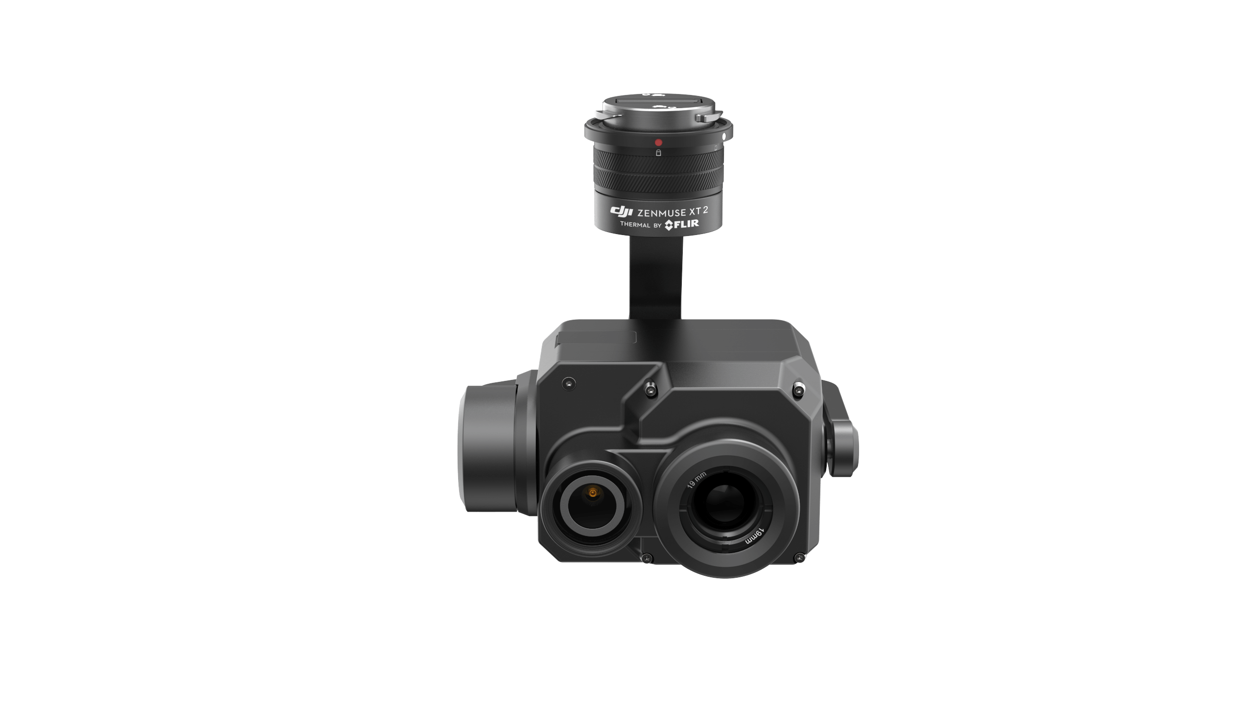
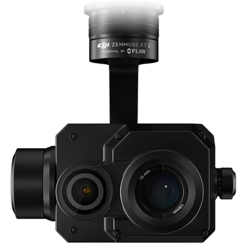
DJI Zenmuse XT2 Thermal Imaging Camera:
For many years, a popular choice for drone operators has been the DJI Zenmuse XT2 payload.
And for good reason.
The XT2 is a robust dual-sensor thermal solution, with a 640 × 512 thermal resolution and a 12MP RGB camera. You can view the visual and thermal imagery simultaneously.
The XT2 can be paired with the M300 RTK - achieving 45 minutes of flight time - as well as the M200 Series V2.
Operators can collect a wealth of data from the XT2, using modes such as Temp Alarm, Heat Track, Temp Check, and Quick Track, as well as switching between various colour palettes.

The XT2 has a 8x digital zoom at 640 x 512, or a 4x digital zoom at 336 x 256.
Praising the XT2-M200 Series set-up, Lee Newman, of London Fire Brigade, said: "We deployed the XT2 at a warehouse fire.
"It can see through smoke and we were able to feedback information to our incident commander.
"This meant he could decide about how he was going to tactically deploy his resources to put out the fire.
"The XT2 and the drone were perfect – they worked, kept crews safe and the incident commander got the information.”
FLIR Vue TZ20-R Thermal Camera
Leading thermal-imaging company FLIR unveiled the FLIR Vue TZ20 in August 2020. But this was replaced in 2021 with the TZ20-R: Essentially the same camera but with radiometric capabilities.
This plug-and-play payload provides a wide 95° field of view (FOV) to cover large areas during a single flight.
It also has a narrow 18° FOV to instantly put more pixels on target.

The three-axis gimbalised camera has a 20x thermal zoom to further support situational awareness.
Operators can gather clear data through the two 640 × 512 radiometric Boson cameras and record clear imagery with the VGA thermal camera module.
The camera is a robust solution, with a -20°C to 60°C (-4°F to 140°F) operating temperature range.
The TZ20-R is compatible with the DJI M300 RTK and DJI M200 Series V2.
Thermal Drones: A Summary
Thermal imaging is nothing new, but when it is integrated with a drone it becomes an incredibly powerful tool.
Combining thermal and a UAV helps to improve efficiency, reduce costs, and enhance safety.
The growing list of success stories and use cases across a range of industries really highlights the potential of this technology.
To find out more about drones with thermal cameras and purchase the best solution for you, contact heliguy™ by phone or email.
heliguy™ is a DJI Gold Partner headquartered in the UK and offering a managed service to global drone programmes.
With more than 10 years of experience in the industry and serving major enterprise clients across a range of industry verticals, heliguy™ can start, support and scale your enterprise drone programme.
Drones can boost your ROI, increase efficiency and improve safety. To find out how heliguy™ can help you, give us a call or send us an email.

Leave a comment