

Following the launch of DJI's Mavic 2 Enterprise Dual, heliguy™ Insider takes a look at how this drone with thermal camera and standard RGB sensor can play a crucial role in saving lives, fighting fires and carrying out utility inspections.
After much-anticipation - including several cryptic promotional Twitter messages from DJI - the new UAV was officially unveiled yesterday. And the Chinese-based technology giant's latest release has the tools to be a real game-changer for a cross-section of users, including those at the very heart of public safety.
The Mavic 2 Enterprise Dual features the compact design of DJI’s Mavic 2 Series drones, with the same array of advanced controls and accessories found in the Mavic 2 Enterprise, including the vitally-important loudspeaker, dual spotlight and beacon.
But the real string to the Dual's bow is its ability to capture thermal images - a key piece of technology which has a proven track record and provides pilots with a reliable tool to operate better, safer and quicker in challenging environments.
The ability of thermal cameras to see differences in heat and to see through
smoke makes them an invaluable tool
Dave Lee, from FLIR DELTA (Drone Education Lab for Thermal Applications)
Developed in partnership with FLIR Systems - the world's largest commercial company specialising in the design and production of thermal-imaging cameras, components and imaging sensors - the Mavic 2 Enterprise Dual features a three-axis gimbal-stabilised camera housing a side-by-side 4K sensor for capturing visible light and a FLIR Lepton thermal microcamera for capturing thermal data.
Together, these sensors allow pilots to perform flights at night, as well as fly in complex daytime conditions like fog and smoke. Users can select from multiple intelligent display modes in the DJI Pilot flight control app to visualise data from the dual-sensor camera. These are:
FLIR’s patented MSX, or multispectral dynamic imaging, embosses high-fidelity, visible light details onto the thermal imagery in real time to enhance visual details, helping pilots quickly identify and interpret critical data that may not be immediately visible to the naked eye.
Displays the average temperature of an object, helping pilots monitor and measure critical or hazardous objects while maintaining a safe distance.
Displays the average, lowest and highest temperature, as well as the corresponding locations of each area, allowing inspectors to quickly assess objects and determine if an asset may be overheating.
Allows pilots to designate specific temperature ranges to be displayed using a custom colour palette so objects within the range relay higher contrast and better visibility. This feature includes custom profiles to aid search and rescue pilots in identifying people and to help firefighters identify hot-spots in fires, as well as a custom profile setting for added flexibility.
How can thermal imaging help me?
While it's fair to say that thermal imaging is nothing new, integrating this technology onto drones for inspection adds a whole another layer of efficiency and safety.
This is the case for a number of reasons, including the fact that the UAV can cover large areas, and more quickly, and add a bird's-eye view of an incident - providing a different and often crucial perspective. This in-turn allows operators to make real-time strategic decisions, often away from the danger zone, while also keeping tabs on crew members.
And there are many examples of this.
-
![]()
Finding missing people -
![]()
Uncovering a cannabis farm -
![]()
Crowd surveillance -
![]()
Firefighting


Thermal imaging and the police
Wiltshire Police used a drone with thermal capabilities to find an 83-year-old woman.
A large on-the-ground team was sent to search a wooded area near to where she was last seen, while the police drone, equipped with a thermal-imaging camera, was dispatched and arrived at the scene around 30 minutes later.
Within an hour, the drone's thermal camera located a heat source on the edge of a wooded area and on closer inspection, the outline of a person laying on the ground could be seen.
The drone hovered over the area directly above to guide officers on the ground in and the patient was located. She had been outside for more than five hours and was suffering
-
![]()
Woman located…. -
![]()
….officers guided to her.


Wiltshire Police aren't the only Force to have gained a positive result by equipping a UAV with a thermal camera.
In June, Lincolnshire Police's drone unit landed its first successful prosecution after a man was jailed for three years for producing cannabis.
Following a scouting mission, and as a result of evidence captured by the drone, a cannabis farm was found. It was a significant discovery, with the site described by police as a professional cannabis growing operation which could produce more than £50,000 worth of the Class B drug. And thermal imaging was key.
Where this man lived was surrounded by trees and bushes, so it was actually like a compound. Our intelligence officers spoke with our drone operators and asked if our drone’s thermal imaging could help – we agreed this could work and started our operation at
2am one morning. We turned up and flew the drone 400ft across an open field, before hovering 50m from the property. The heat source was obvious and we scrolled through our different filters to highlight the heat in a number of different spectrums. It was great to be able to show this evidence in court as it provides a visual that couldn’t really have been done in any other way
Lincolnshire Police spokesman, recalling the night of the operation
Thermal imaging and fighting fires with drones
FLIR DELTA has produced a series of online tutorials and guides in relation to drones and thermal cameras. In Episode 10, Dave Lee hosts a useful presentation entitled Using Thermal Drones to Assist Fire Fighting Operations. He begins the episode by explaining just how vital this technology can be.

"There are many ways that thermal drones can support the life-saving missions of fire departments, large and small.
"The ability of a thermal camera to see differences in heat and see through smoke make them an invaluable tool for fighting structure fires, wildfires and forest fires."
Dave Lee, FLIR DELTA
He's right. And there are many reasons for this!
Firstly, they can see through smoke, as this video shows - allowing operators to see people in need, keep tabs on officers and see the head and edge of wildfires.
Pairing a thermal camera with a drone has a host of other benefits, such as detecting hot-spots and providing valuable information about roof integrity, flow paths and wet lines.
Here are Dave Lee's thoughts about these benefits:
Roof Integrity
"Drone thermal imaging can give crews vital information about the structural integrity of the roof they are working on, especially when coupled with isotherms. Areas that are getting hot enough and in danger of burn-through will show up clearly, so crews can be re-positioned before the structure collapses."
Flow-path Analysis
"Thermal imaging also provides flow-path analysis. Being able to see the flow path of
Wet Lines
"Wet lines are used to control the spread of a fire by watering down burnable material ahead of a fire, but they won't be as effective if there are breaks or holes in them. Thermal cameras give crews instant feedback on the integrity of their wet lines."
Hot-spots
"After the obvious parts of the fire are out, crews put a lot of effort into making sure there aren't any smouldering areas that could flare up later. Thermal cameras on drones are perfect for this because they can cover such a wide area quickly. Drone operators can guide crews to specific hot-spots that might have gone undetected."
Drone Utility Inspections
A drone equipped with a thermal camera can be a game-changer for utility inspections, both in terms of safety and efficiency.


Substations and electrical-transmission lines have been inspected for years, but traditional methods involve specialist tools and techniques to do it. Inspecting substations, for instance, can require handheld cameras, often with heavy, long-range lenses, while using manned helicopters to check out electrical-transmission lines is an expensive technique, not to mention dangerous, as the aircraft has to fly dangerously close to the lines.
This is where drones come in and companies around the world are discovering the benefits of carrying out inspections with UAVs. And here's why:

Cost: Thermal and visible cameras can be more cost effective than other inspection methods, both in terms of operational cost and time required.
Fast results: Unlike other methods, drones provide immediate images, yielding quicker repairs, less downtime and increased reliability.
Thermal imaging drones can also be used for building inspections, letting you see
Other perks of the Mavic 2 Enterprise Dual
While the thermal-imaging capability of the DJI Mavic 2 Enterprise Dual dual is the drone's highlight, this impressive newbie has an array of impressive features.
The Mavic 2 Enterprise Dual is compatible with the full line of Mavic 2 Enterprise accessories. They are securely mounted to the drone’s body and operated through the DJI Pilot flight-control app.
These accessories open new paths for pilots to communicate and work from the air, moving drones beyond imaging tools and into configurable platforms that enhance mission productivity. These accessories are:
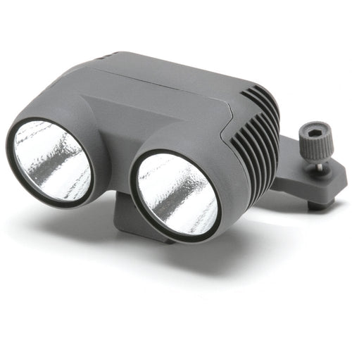
Spotlight


A dual spotlight with a brightness of 2,400 lumens aids operators in carrying out missions in dark or low-light areas.
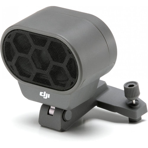
Speaker


A loudspeaker with a maximum projection of 100 decibels (1-meter distance) lets pilots play up to 10 custom voice recordings on demand, providing a communications channel to nearby individuals that can be critical during life-saving emergency operations.
Beacon
Designed with US Federal Aviation Administration Night Waiver standards in mind, the Beacon features a bright flashing strobe visible three miles away. This helps pilots carry out missions in low-light conditions or at night much more safely, and provides additional airspace awareness for operators of nearby drones and traditional aircraft.
Enhanced Data Security Features
Mavic 2 Enterprise Dual includes the same features as Mavic 2 Enterprise to protect the integrity of photos, videos, flight logs and other data generated during sensitive flights.
It incorporates 24GB of on-board data storage and password protection, creating accountability for all access to the drone’s functions and stored data.

When Password Protection is enabled, users are required to enter their password each time they activate the drone, link the remote controller with the drone and access the drone’s

In addition, a GPS timestamping feature encodes the time, date and location of every recorded image taken by the visual camera, aiding in pilot accountability and ensuring that data captured by the drone can be trusted and used in situations from reviewing critical infrastructure inspections to potential legal proceedings.
Mavic 2 Enterprise Dual users with heightened data security concerns can use the Local Data Mode feature in the DJI Pilot App which, when activated, will stop the user’s connected mobile device from sending or receiving any data over the internet. This provides added security assurances for operators of flights involving critical infrastructure, governmental projects or other sensitive missions.
Improving Flight and Airspace Safety
Every Mavic 2 Enterprise Dual comes equipped with DJI’s AirSense technology to help ensure drones remain a safe addition to the skies.
AirSense improves pilots’ situational awareness and enhances airspace safety by automatically alerting drone pilots of ADS-B signals from nearby planes and helicopters and by sending real-time positioning alerts through the DJI Pilot flight-control app.
Mavic 2 Enterprise Dual features DJI’s most advanced video and data transmission system, Ocusync 2.0, providing a more stable connection between the drone and its remote controller, even in environments with high electromagnetic interference, such as urban areas.
The system features stronger interference resistance and auto-switching capabilities that support both 2.4 GHz and 5.8 GHz frequency bands with the capability to use different frequencies for uplink and downlink data streams.

The foldable and portable drone uses DJI’s FOC propulsion motors combined with efficient propellers for quieter and more efficient flight, delivering a maximum flight time of up to 31 minutes and a top speed of 72 kph (45 mph).
In addition, a self-heating battery allows the drone to perform reliably in adverse weather conditions as low as -10 Celsius (14 Fahrenheit).
How much does this thermal drone cost?

The Mavic 2 Enterprise Dual Universal Edition, which includes the aircraft, a remote controller, one battery, all three mountable accessories and a protector case with flight tools, is £2,669. The estimated shipping date is at the end of December 2018 and is available to pre-order now from Heliguy.

Leave a comment