
- GIS expert Ben Sangster joins Heliguy's enterprise drone team;
- He will offer specialist advice on drone mapping, photogrammetry, surveying and LiDAR;
- Ben will help clients choose the best drones for their missions, guide them through software packages and help them analyse data;
- Major heliguy™ clients such as Balfour Beatty and Terra Drone Europe are already using drones for mapping and surveying.
heliguy™ has bolstered its enterprise team by employing a GIS expert to help surveyors maximise their drone programmes, utilise collected data and increase return on investment.
Ben Sangster has joined heliguy™ to provide comprehensive workflow support to our commercial clients, with a focus on spatial mapping, photogrammetry, surveying, and LiDAR.

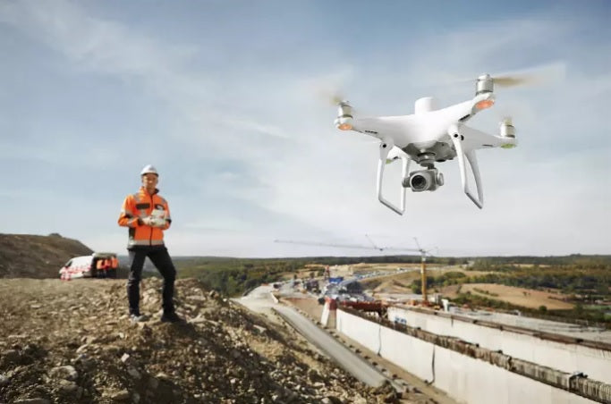
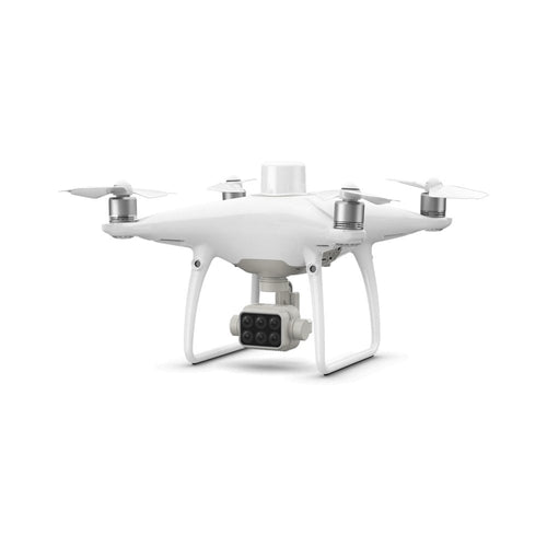
He will be offering specialist and dedicated advice on the best industry-specific hardware, including DJI’s next-gen mapping drone the Phantom 4 RTK, plus the M210 RTK Series V2 aircraft.
Ben will guide clients through software and drone data platforms built for architecture, engineering, and construction professionals, such as 3DR Site Scan, DroneDeploy, and Pix4D. He will also be on hand to assist any aspect of their drone missions.

The heliguy™ team has decades of experience in this sector. Adding Ben to the ranks strengthens this area of expertise and he joins a company which is already the go-to drone supplier for the likes of Balfour Beatty, Network Rail, Terra Drone Europe, and Sellafield Sites.
I have experience in all aspects of photogrammetry, spatial mapping, surveying, and geospatial data. I am excited to assist heliguy™ clients by applying this experience to their situation.
Ben Sangster, Heliguy
Prior to joining heliguy™, Ben graduated with a BSc in Geographical Information Science at Newcastle University and was employed as a land surveyor.
He is now relishing the chance to work with our enterprise clients to offer direct customer service and consultancy and to help start, support or scale their drone programmes.

Drones have become vital tools for surveying and construction, helping to collect fast and accurate data, accessing hard-to-reach areas and improving on-site safety.
heliguy™ Insider speaks to Ben about his previous GIS work and how he will utilise this to benefit our clients.
What Is Your GIS Experience?
I am a Newcastle University graduate with a BSc degree in Geographical Information Science which gave me essential experience in all aspects of photogrammetry, spatial mapping and surveying.
I moved onto employment as a land surveyor in which my knowledge has been confounded and I developed an understanding of the many problems which arise when dealing with geospatial data. I am excited to use this experience to assist heliguy™ clients by applying my experience to their situation.

Most significantly, a project commissioned by the Environment Agency meant I was part of a team which traditionally surveyed the coastline from Scarborough to Alnwick. Large projects similar to this could be completed much quicker using drones at a higher level of accuracy.
How Will You Use This Experience To Benefit heliguy™ Clients?
My role at heliguy™ is to support clients using drones for mapping and surveying by using the experience I have gained in the field. I will specialise in RTK (real-time kinematic) drones which obtain survey-grade accuracy, but I can also advise on non-RTK drones for mapping.
I will also provide information, advice and customer support to clients interested in LiDAR solutions, the fastest growing area in the geospatial market.

The support I will offer to clients will include drone flight software and hardware, as well as flight and processing advice. In a nutshell, it will be complete workflow support.
I also want to make drone data accessible and useful across all industries, helping our clients to improve their site communications, planning, and operations.
I intend to utilise Heliguy’s ecosystem of hardware and software to offer advice and guidance on a range of drone-surveying problems and to build tailored solutions specific to individual needs.

What Are The Main Benefits Of Using Drones For Surveying?
There are numerous benefits of using drones for surveying and mapping.

First of all, they are far more efficient than traditional, manual methods. Something which would take a couple of people two days in the field to complete can now be done in a few hours with a drone.
Drone mapping missions benefit from software platforms, which help businesses manage complex job sites. These software platforms automate everything from flight to analysis, allowing teams to survey large areas and make informed decisions quickly and accurately.
Using drones also allow for safer operations, especially when working on construction sites. They reach difficult-to-access areas and reduce hazardous man-hours.
Drone surveying can also produce a variety of deliverables with use cases in many industries. For example, surveying software can stitch together hundreds or thousands of digital photos captured by your drone to produce high-quality 2D orthomosaic maps, or large numbers of digital photos of your surveying site can be compiled into a 3D orthomosaic map to provide actionable topographic data.

How Are Major Companies Using Drones To Enhance Their Operations?
heliguy™ supplies and supports the drone programmes of major companies like Balfour Beatty, Terra Drone Europe, and Network Rail who are using unmanned aircraft to benefit their operations in numerous ways.
For example, Balfour Beatty has utilised drones, including the DJI Phantom 4 RTK, on a major smart motorway development in The Midlands.

The drones are saving the company huge amounts of time.
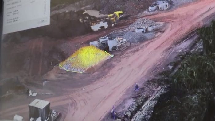
For example, measuring stockpiles and earthworks at the scheme’s recycling depot at Junction 2. It would take a surveyor, using traditional handheld equipment, about a day to measure these stockpiles and process the data. But Balfour Beatty has found that they can fly the drone over the compound in 15 minutes and process the model in about two hours.

Digitising a site is a huge time saver and it also increases health and safety, making it safer to gain these quantities by taking people out of dangerous situations.
Other heliguy™ clients, such as Terra Drone Europe, have used the DJI Phantom 4 RTK for a variety of jobs, including an important international survey of breakwaters and have carried out an in-depth accuracy test, while Network Rail is utilising drone technology for railway inspections and post-incident analysis - all while keeping the railway open and their people safe.

In Your Experience, Which Drones Do You Recommend?
Heliguy’s drone range contains several RTK-based drones which are suitable for surveying and mapping applications.
The drone most suitable for construction sites and 40 HA+ projects is the DJI Phantom 4 RTK. This, accompanied by an all-in-one software package, such as Pix4D or Drone Deploy, makes it easy for survey companies to head straight out in the field and capture, process and analyse.
Another suitable drone is the DJI M210 RTK V2. This is a more expensive solution than the Phantom 4 RTK, but is a more flexible mapping drone as you can change its payload. It also works with 3DR’s software package, which the Phantom 4 RTK currently does not. The M210 RTK is also more suited to larger enterprise clients who have multiple purposes.

Finally, with DJI’s upcoming release of the Phantom 4 Multispectral this open the door for agricultural clients to get rich information regarding produce health. Multispectral imaging measures bands of the electromagnetic spectrum other than visible light and each band can be used to derive different information from the same image.

To discuss your drone mapping or surveying project with Ben and to find out how heliguy™ can help support, maintain and grow your enterprise drone programme, contact us by phone or email.

Leave a comment